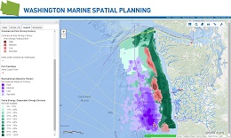
Go to the homepage of Washington Marine Spatial Planning
  • About Us
  • Calendar
  • Mapping Application
  • News
  • Projects and Resources
Loading images...

LEARN

EXPLORE

  • Data Catalog
  • Mapping Application
  • MSP Projects
  • Topic Maps

CONNECT

Explore

Maps, current projects, and data along the Washington coast.

Mapping Application

Explore data layers through this interactive mapping tool. This dynamic interacting mapping tool includes data layers showing human uses, marine life, habitat, physical oceanography of Washington’s coastal waters, and more! This tool is designed to support you in participating in the Marine Spatial Planning process.

    Click here for a step-by-step tutorial on how to use the mapping application.

MSP Projects

View a list of Washington state-funded projects to:

  • Develop comprehensive maps,
  • Complete a marine ecosystem assessment,
  • Engage the public,
  • Develop data tools.

Projects involve federal, state, tribal, and academic organizations that are providing up-to-date, reliable, and relevant information for the Marine Spatial Planning process.

Data Catalog

Download data, metadata, original source information, and web services that provide data layers in various downloadable formats.


  • About Us
  • Calendar
  • Connect
  • Explore
  • Learn
  • News
  • Mapping Application
  • Projects and Resources